© 2010 Naturesfury.net
What is a thunderstorm?
A thunderstorm is a rain shower during which you hear thunder. Since thunder comes from lightning, all thunderstorms have lightning. A thunderstorm is classified as "severe" when it contains one or more of the following: hail three-quarter inch or greater, winds gusting in excess of 50 knots (57.5 mph), tornado.

What is known?
An average thunderstorm is 15 miles in diameter and lasts an average of 30 minutes. At any given moment, there are roughly 2,000 thunderstorms in progress around the world. It is estimated that there are 100,000 thunderstorms each year. About 10% of these reach severe levels.

How does a thunderstorm form?
Three basic ingredients are required for a thunderstorm to form: moisture, rising unstable air (air that keeps rising when given a nudge), and a lifting mechanism to provide the "nudge."

The sun heats the surface of the earth, which warms the air above it. If this warm surface air is forced to rise -- hills or mountains, or areas where warm/cold or wet/dry air bump together can cause rising motion -- it will continue to rise as long as it weighs less and stays warmer than the air around it. As the air rises, it transfers heat from the surface of the earth to the upper levels of the atmosphere (the process of convection). The water vapor it contains begins to cool, releasing the heat, and it condenses into a cloud. The cloud eventually grows upward into areas where the temperature is below freezing. Some of the water vapor turns to ice and some of it turns into water droplets. Both have electrical charges. Ice particles usually have positive charges, and rain droplets usually have negative charges. When the charges build up enough, they are discharged in a bolt of lightning, which causes the sound waves we hear as thunder

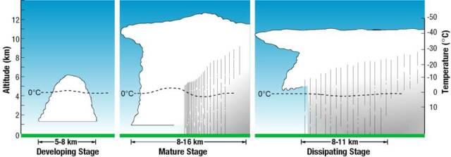
The Thunderstorm Life Cycle
Thunderstorms have a life cycle of three stages: The developing stage, the mature stage, and the dissipating stage.
Thunderstorm FAQs
What Is A Supercell?
Are There Winter Thunderstorms?
A supercell is an often dangerous convective storm with a very organized internal structure including a rotating updraft that allows it to keep going for up to several hours. Supercells are capabile of producing severe weather including high winds, large hail, and strong tornadoes. They are most frequently isolated and often develop in the warm air ahead of a squall line. A supercell also usually forms in an environment with strong vertical wind shear that causes the updraft to begin rotating.
A supercell is an often dangerous convective storm with a very organized internal structure including a rotating updraft that allows it to keep going for up to several hours. Supercells are capabile of producing severe weather including high winds, large hail, and strong tornadoes. They are most frequently isolated and often develop in the warm air ahead of a squall line. A supercell also usually forms in an environment with strong vertical wind shear that causes the updraft to begin rotating.A supercell is an often dangerous convective storm with a very organized internal structure including a rotating updraft that allows it to keep going for up to several hours. Supercells are capabile of producing severe weather including high winds, large hail, and strong tornadoes. They are most frequently isolated and often develop in the warm air ahead of a squall line. A supercell also usually forms in an environment with strong vertical wind shear that causes the updraft to begin rotating.A supercell is an often dangerous convective storm with a very organized internal structure including a rotating updraft that allows it to keep going for up to several hours. Supercells are capabile of producing severe weather including high winds, large hail, and strong tornadoes. They are most frequently isolated and often develop in the warm air ahead of a squall line. A supercell also usually forms in an environment with strong vertical wind shear that causes the updraft to begin rotating.
A supercell is an often dangerous convective storm with a very organized internal structure including a rotating updraft that allows it to keep going for up to several hours. Supercells are capabile of producing severe weather including high winds, large hail, and strong tornadoes. They are most frequently isolated and often develop in the warm air ahead of a squall line. A supercell also usually forms in an environment with strong vertical wind shear that causes the updraft to begin rotating.
Winter thunderstorms are rare because the air is more stable strong updrafts cannot form because the surface temperatures during the winter are colder.
Winter thunderstorms are rare because the air is more stable strong updrafts cannot form because the surface temperatures during the winter are colder. Winter thunderstorms are rare because the air is more stable strong updrafts cannot form because the surface temperatures during the winter are colder. Winter thunderstorms are rare because the air is more stable strong updrafts cannot form because the surface temperatures during the winter are colder.
Winter thunderstorms are rare because the air is more stable strong updrafts cannot form because the surface temperatures during the winter are colder.
The developing stage of a thunderstorm is marked by a cumulus cloud that is being pushed upward by a rising column of air (updraft). The cumulus cloud soon looks like a tower (called towering cumulus) as the updraft continues to develop. There is little to no rain during this stage but occasional lightning. The developing stage lasts about 10 minutes.

The thunderstorm enters the mature stage when the updraft continues to feed the storm, but precipitation begins to fall out of the storm, and a downdraft begins (a column of air pushing downward). When the downdraft and rain-cooled air spreads out along the ground it forms a gust front, or a line of gusty winds. The mature stage is the most likely time for hail, heavy rain, frequent lightning, strong winds, and tornadoes. The storm occasionally has a black or dark green appearance.

Eventually, a large amount of precipitation is produced and the updraft is overcome by the downdraft beginning the dissipating stage. At the ground, the gust front moves out a long distance from the storm and cuts off the warm moist air that was feeding the thunderstorm. Rainfall decreases in intensity, but lightning remains a danger.
Click image to enlarge
Image Courtesy of NOAA
Why do some thunderstorm have a greenish hue?
Why doesn't the west coast of the U.S. experience more thunderstorms?
There is less convection on the west coast in part because of the cool water temperatures off shore in the Pacific Ocean. That impacts the temperature of air that moves inland, making it generally more stable and less convective; convection = thunderstorms). To get thunder you need strong updrafts (convection), which means rapidly falling temperatures with height (vertically) in the atmosphere.
There is less convection on the west coast in part because of the cool water temperatures off shore in the Pacific Ocean. That impacts the temperature of air that moves inland, making it generally more stable and less convective; convection = thunderstorms). To get thunder you need strong updrafts (convection), which means rapidly falling temperatures with height (vertically) in the atmosphere.There is less convection on the west coast in part because of the cool water temperatures off shore in the Pacific Ocean. That impacts the temperature of air that moves inland, making it generally more stable and less convective; convection = thunderstorms). To get thunder you need strong updrafts (convection), which means rapidly falling temperatures with height (vertically) in the atmosphere.There is less convection on the west coast in part because of the cool water temperatures off shore in the Pacific Ocean. That impacts the temperature of air that moves inland, making it generally more stable and less convective; convection = thunderstorms). To get thunder you need strong updrafts (convection), which means rapidly falling temperatures with height (vertically) in the atmosphere.
There is less convection on the west coast in part because of the cool water temperatures off shore in the Pacific Ocean. That impacts the temperature of air that moves inland, making it generally more stable and less convective; convection = thunderstorms). To get thunder you need strong updrafts (convection), which means rapidly falling temperatures with height (vertically) in the atmosphere.
Why does the sky sometimes turn orange after a thunderstorm?
Why are some clouds darker than others?
No one really knows what causes thunderstorm clouds to look green at times. It could have something to do with sunlight refracting through the storm.
No one really knows what causes thunderstorm clouds to look green at times. It could have something to do with sunlight refracting through the storm.No one really knows what causes thunderstorm clouds to look green at times. It could have something to do with sunlight refracting through the storm.No one really knows what causes thunderstorm clouds to look green at times. It could have something to do with sunlight refracting through the storm.
No one really knows what causes thunderstorm clouds to look green at times. It could have something to do with sunlight refracting through the storm.
Most thunderstorms occur in the late afternoon. By this time of day, the sun is setting. The orange hue is caused by the same process that causes the vivid colors at sunsets. Shorter wavelengths of light (blue) are scattered quickly, leaving only the yellow-orange-red end of the spectrum.
Most thunderstorms occur in the late afternoon. By this time of day, the sun is setting. The orange hue is caused by the same process that causes the vivid colors at sunsets. Shorter wavelengths of light (blue) are scattered quickly, leaving only the yellow-orange-red end of the spectrum.Most thunderstorms occur in the late afternoon. By this time of day, the sun is setting. The orange hue is caused by the same process that causes the vivid colors at sunsets. Shorter wavelengths of light (blue) are scattered quickly, leaving only the yellow-orange-red end of the spectrum.Most thunderstorms occur in the late afternoon. By this time of day, the sun is setting. The orange hue is caused by the same process that causes the vivid colors at sunsets. Shorter wavelengths of light (blue) are scattered quickly, leaving only the yellow-orange-red end of the spectrum.
Most thunderstorms occur in the late afternoon. By this time of day, the sun is setting. The orange hue is caused by the same process that causes the vivid colors at sunsets. Shorter wavelengths of light (blue) are scattered quickly, leaving only the yellow-orange-red end of the spectrum.
As far as why some clouds are darker than others, it has to do with the amount of sunlight that is able to penetrate the cloud. The thicker the cloud, the less sunlight can come through . If there is a cirrus cloud (high level, thin and wispy) above another cloud, it could shade the lower cloud and make it a little darker. The size of the water droplets that make up the cloud also has an effect on how much sunlight gets through as well, with smaller drop sizes blocking more sunlight.
As far as why some clouds are darker than others, it has to do with the amount of sunlight that is able to penetrate the cloud. The thicker the cloud, the less sunlight can come through . If there is a cirrus cloud (high level, thin and wispy) above another cloud, it could shade the lower cloud and make it a little darker. The size of the water droplets that make up the cloud also has an effect on how much sunlight gets through as well, with smaller drop sizes blocking more sunlight. As far as why some clouds are darker than others, it has to do with the amount of sunlight that is able to penetrate the cloud. The thicker the cloud, the less sunlight can come through . If there is a cirrus cloud (high level, thin and wispy) above another cloud, it could shade the lower cloud and make it a little darker. The size of the water droplets that make up the cloud also has an effect on how much sunlight gets through as well, with smaller drop sizes blocking more sunlight. As far as why some clouds are darker than others, it has to do with the amount of sunlight that is able to penetrate the cloud. The thicker the cloud, the less sunlight can come through . If there is a cirrus cloud (high level, thin and wispy) above another cloud, it could shade the lower cloud and make it a little darker. The size of the water droplets that make up the cloud also has an effect on how much sunlight gets through as well, with smaller drop sizes blocking more sunlight.
As far as why some clouds are darker than others, it has to do with the amount of sunlight that is able to penetrate the cloud. The thicker the cloud, the less sunlight can come through . If there is a cirrus cloud (high level, thin and wispy) above another cloud, it could shade the lower cloud and make it a little darker. The size of the water droplets that make up the cloud also has an effect on how much sunlight gets through as well, with smaller drop sizes blocking more sunlight.
What Is SKYWARN?
SKYWARN is a National Weather program that is run by and coordinated by the NWS. It was a concept developed in the early 1970's that was intended to promote a cooperative effort between the National Weather Service and its communities. The emphasis of the effort is often focused on the storm spotter, a volunteer who takes a position near their community and reports wind gusts, hail size, rainfall, and cloud formations that could signal a developing tornado. Another part of SKYWARN is the receipt and effective distribution of NWS information.