© 2010 Naturesfury.net

Information on this page courtesy of NOAA / PMEL / Center for Tsunami Research
world. Predicting when and where the next tsunami will strike is currently impossible. Once the tsunami is generated, forecasting tsunami arrival and impact is possible through modeling and measurement technologies.
Generation
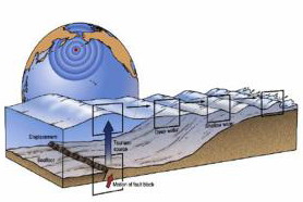
Tsunamis are most commonly generated by earthquakes in marine and coastal regions. Major tsunamis are produced by large (greater than 7 on the Richer scale), shallow focus (< 30km depth in the earth) earthquakes associated with the movement of oceanic and continental plates. They frequently occur in the Pacific, where dense oceanic plates slide under the lighter continental plates. When these plates fracture they provide a vertical movement of the seafloor that allows a quick and efficient transfer of energy from the solid earth to the ocean. Underwater landslides associated with smaller earthquakes are also capable of generating destructive tsunamis. Other large-scale disturbances of the sea -surface that can generate tsunamis are explosive volcanoes and asteroid impacts.
Wave Propagation
Because earth movements associated with large earthquakes are thousand of square kilometers in area, any vertical movement of the seafloor immediately changes the sea-surface. The resulting tsunami propagates as a set of waves whose energy is concentrated at wavelengths corresponding to the earth movements (~100 km), at wave heights determined by vertical displacement (~1m), and at wave directions determined by the adjacent coastline geometry. Because each earthquake is unique, every tsunami has unique wavelengths, wave heights, and directionality. From a tsunami warning perspective, this makes the problem of forecasting tsunamis in real time daunting.
Warning Systems
Since 1946, the tsunami warning system has provided warnings of potential tsunami danger in the pacific basin by monitoring earthquake activity and the passage of tsunami waves at tide gauges. However, neither seismometers nor coastal tide gauges provide data that allow accurate prediction of the impact of a tsunami at a particular coastal location. Monitoring earthquakes gives a good estimate of the potential for tsunami generation, based on earthquake size and location, but gives no direct information about the tsunami itself. Tide gauges in harbors provide direct measurements of the tsunami, but the tsunami is significantly altered by local bathymetry and harbor shapes, which severely limits their use in forecasting tsunami impact at other locations. Partly because of these data limitations, 15 of 20 tsunami warnings issued since 1946 were considered false alarms because the tsunami that arrived was too weak to cause damage.
What is a Tsunami?
A Tsunami is a set of ocean waves caused by any large, abrupt disturbance of the sea-surface. If the disturbance is close to the coastline, local tsunamis can demolish coastal communities within minutes. A very large disturbance can cause local devastation AND export tsunami destruction thousands of miles away. The word tsunami is a Japanese word, represented by two characters: tsu, meaning, "harbor", and nami meaning, "wave". Tsunamis rank high on the scale of natural disasters. Since 1850 alone, tsunamis have been responsible for the loss of over 420,000 lives and billions of dollars of damage to coastal structures and habitats. Most of these casualties were caused by local tsunamis that occur about once per year somewhere in the
Forecasting impacts
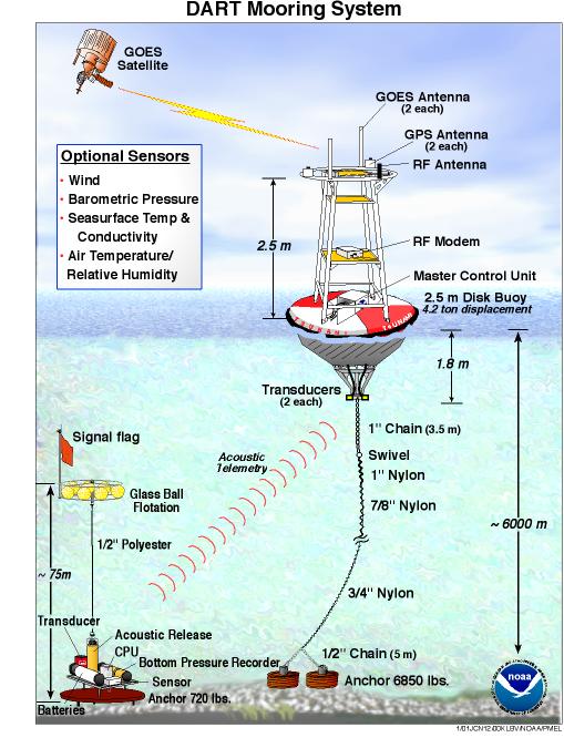
Recently developed real-time, deep ocean tsunami detectors or DART® Mooring System (Figure 1) will provide the data necessary to make tsunami forecasts.
A DART® system consists of a seafloor bottom pressure recording (Figure 2) system capable of detecting tsunamis as small as 1 cm, and a moored surface buoy (Figure 3) for real-time communications. An acoustic link is used to transmit data from the BPR on the seafloor to the surface buoy. The data are then relayed via a GOES satellite link to ground stations, which demodulate the signals for immediate dissemination to NOAA's Tsunami Warning Centers and PMEL. Click Here for example animation.
How the DART Network helps forecasting:
When a tsunami event occurs, the first information available about the source of the tsunami is based only on the available seismic information for the earthquake event. As the tsunami wave propagates across the ocean and successively reaches the DART systems, these systems report sea level information measurements back to the Tsunami Warning Centers, where the information is processed to produce a new and more refined estimate of the tsunami source.The result is an increasingly accurate forecast of the tsunami that can be used to issue watches, warnings or evacuations.
Reduction of impact
The recent development of real-time deep ocean tsunami detectors and tsunami inundation models has given coastal communities the tools they need to reduce the impact of future tsunamis. If these tools are used in conjunction with a continuing educational program at the community level, at least 25% of the tsunami related deaths might be averted.
Click the link to see a real-time deep ocean tsunami detection system responding to a tsunami generated by seismic activity.


Figure 3
Figure 2
Figure 1